Public toilets in Strasbourg
Ever wandered around a city desperately looking for a public toilet? Fear not, the open data movement is here to help. The city of Strasbourg recently opened a new open data portal and while checking their available data sets I came across the one about public toilets. I guess every city should leak information about their public toilets.
I accessed the data by using an API and made a little map showing where to find the toilets.
# Load packages
library(httr)
library(jsonlite)
library(tidyverse)
library(sf)
library(ggmap)
library(ggrepel)
# Create response object
url <- "https://data.strasbourg.eu/api/records/1.0/search/?dataset=lieux_toilettes_publiques"
raw.result <- GET(url)
# Check response object
status_code(raw.result)
# Access raw json data and transform into data frame
json_text <- content(raw.result, "text")
names(fromJSON(json_text))
records <- fromJSON(json_text)$records
toilettes <- records$fields
# Check data and select necessary variables
names(toilettes)
toilettes <- toilettes %>%
select(name, point_geo) %>%
rename(geometry = point_geo)
# Get rid of part of the string and capitalize the first letter of the remaining part
firstup <- function(x) {
substr(x, 1, 1) <- toupper(substr(x, 1, 1))
x
}
toilettes <- toilettes %>%
mutate(name = firstup(str_split(toilettes$name, "Toilettes publiques ", simplify = TRUE)[,2]))
# Check data again
toilettes
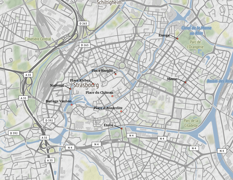
# There are 10 public toilets in Strasbourg
# Let's plot them on a map
# First, extract geographic location and save as dataframe
geo_seq <- unlist(toilettes$geometry)
lat <- geo_seq[seq(1, length(geo_seq), 2)]
lon <- geo_seq[seq(2, length(geo_seq), 2)]
toilettes_geo <- toilettes %>%
mutate(lat = lat, lon = lon) %>%
select(name, lat, lon)
toilettes_geo
toilettes_sf <- st_as_sf(toilettes_geo, coords = c("lon", "lat"),
crs = 4326, agr = "constant")
# Second, get the background map
# Find coordinates with the website https://boundingbox.klokantech.com/
stras_map <- get_map(c(7.716782,48.564086,7.787678,48.600426),
maptype = "toner-background")
# Third, combine the two geographic data sets
ggmap(stras_map, extent = "device") +
geom_sf(data = toilettes_sf,
inherit.aes =FALSE,
colour="#238443",
fill="red",
alpha=.5,
size=2,
shape=21) +
geom_text_repel(data = toilettes_sf,
aes(x = lon, y = lat, label = name),
size = 2.9,
col = "black",
fontface = "bold",
nudge_x = -0.004,
nudge_y = +0.0007)
# One toilet is not on the map, it is the one it Schiltigheim, which is in the north of Strasbourg.
Here is the final result:
PS: Public toilets in France are free.
Get the code here.